


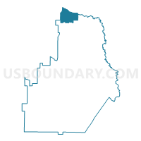
153NSES - NSES Voting District, Houston County, Georgia
About
Outline

Summary
| Unique Area Identifier | 562231 |
| Name | 153NSES - NSES Voting District |
| County | Houston County |
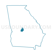
| State | Georgia |
| Area (square miles) | 8.97 |
| Land Area (square miles) | 8.83 |
| Water Area (square miles) | 0.13 |
| % of Land Area | 98.50 |
| % of Water Area | 1.50 |
| Latitude of the Internal Point | 32.66237670 |
| Longtitude of the Internal Point | -83.68329570 |
Maps

Graphs
Select a template below for downloading or customizing gragh for 153NSES - NSES Voting District, Houston County, Georgia


Neighbors
Neighoring Voting District (by Name) Neighboring Voting District on the Map
- 021RU1 - RUTLAND 1 Voting District, Bibb County, GA
- 021RU2 - RUTLAND 2 Voting District, Bibb County, GA
- 0795 - DISTRICT 5 Voting District, Crawford County, GA
- 153CENT - CENT Voting District, Houston County, GA
- 153ELBC - ELBC Voting District, Houston County, GA
- 153MALL - MALL Voting District, Houston County, GA
- 153NSMS - NSMS Voting District, Houston County, GA
- 225B1 - BYRON #1 Voting District, Peach County, GA
- 225B2 - BYRON #2 Voting District, Peach County, GA
Top 10 Neighboring County Subdivision (by Population) Neighboring County Subdivision on the Map
- Warner Robins CCD, Houston County, GA (110,876)
- Rutland CCD, Bibb County, GA (12,616)
- Byron CCD, Peach County, GA (11,564)
- Zenith CCD, Crawford County, GA (8,979)
Top 10 Neighboring Place (by Population) Neighboring Place on the Map
Top 10 Neighboring Unified School District (by Population) Neighboring Unified School District on the Map
- Bibb County School District, GA (155,547)
- Houston County School District, GA (138,730)
- Peach County School District, GA (27,695)
- Crawford County School District, GA (12,630)
Top 10 Neighboring State Legislative District Lower Chamber (by Population) Neighboring State Legislative District Lower Chamber on the Map
- State House District 136, GA (56,696)
- State House District 140, GA (46,613)
- State House District 145, GA (43,689)
Top 10 Neighboring State Legislative District Upper Chamber (by Population) Neighboring State Legislative District Upper Chamber on the Map
- State Senate District 18, GA (181,223)
- State Senate District 14, GA (158,067)
- State Senate District 26, GA (135,905)
Top 10 Neighboring 111th Congressional District (by Population) Neighboring 111th Congressional District on the Map
Top 10 Neighboring Census Tract (by Population) Neighboring Census Tract on the Map
- Census Tract 401.02, Peach County, GA (9,934)
- Census Tract 201.09, Houston County, GA (8,685)
- Census Tract 135.04, Bibb County, GA (8,575)
- Census Tract 201.05, Houston County, GA (6,018)
- Census Tract 702.01, Crawford County, GA (5,851)
- Census Tract 201.08, Houston County, GA (5,812)
- Census Tract 201.06, Houston County, GA (2,859)
- Census Tract 135.02, Bibb County, GA (1,927)